Monday, November 12, 2018
Southern California's Woolsey Fire, As Seen From Space
Over the last three days, Southern California has been under siege, as "Red Flag" weather conditions and one of the warmest and driest summers on record for the region helped turn two fires--the Hill Fire, started in Thousand Oaks on Thursday, and the Woolsey Fire, started near the old Rocketdyne site in Simi Valley--into a raging inferno, consuming 85,500 acres in the Woolsey Fire and 4,531 acres in the Hill Fire, all between Los Angeles County and Ventura County. 179 structures were tallied as destroyed as of 10:00pm on Sunday evening, and hundreds of thousands of residents evacuated at one time, with continuing evacuations and displacements of entire cities and communities.
Here are some images of Southern California's Woolsey Fire, as seen from space and aerial sensors.
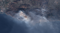
Below: Satellite image of the Woolsey Fire (visual spectrum), via the EU's Sentinel-2 satellite on Saturday, November 10, 2018. Click for larger image.

Below: Outline of the burn areas in the Woolsey Fire, via the EU's Sentinel-2 satellite on Saturday, November 10, 2018. Click for larger image.

Below: A live, frequently updated map of fire detections, drawn from NASA's MODIS and VIIRS sensors, along with infrared mapping flights by fire mapping planes, courtesy Joseph Effelt.
Editor's note: Our apologies to our readers who use our service for keeping up on technology and finance news for our lack of coverage on Friday, as we were evacuated at 3am on Thursday morning as flames approached Thousand Oaks, and our homes and servers have been within the mandatory evacuation zones. Flames in Westlake Village came within a couple of blocks of our Internet servers, but we were luckily unscathed and remained up the whole time. Those interested in continued play-by-play coverage on the fire may be interested in following a personal Twitter account created by editor/founder Benjamin Kuo here.