Wednesday, December 6, 2017
Stunning Satellite Image Shows Southern California Burning
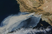 NASA released a stunning satellite image on Tuesday afternoon, showing the vast plume of smoke coming from Southern California's plague of wildfires, including the Thomas Fire in Ventura County, the Creek Fire in Los Angeles, and the Rye Fire straddling the LA and Ventura County line. NASA said the image was captured by the Moderate Resolution Imaging Spectroradiometer (MODIS) on its NASA Terra satellite on Tuesday afternoon. All three fires were sparked by an unusually strong Santa Ana wind event, which has triggered a Red Flag warning into the weekend. According to the National Weather Service, there will be elevated fire weather conditions with very dry air through at least early next week.