Wednesday, February 7, 2018
Mayan Civilization Uncovered By Teledyne LiDAR
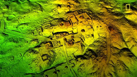 The vast reaches of Mayan civilization--described in the new National Geographic special, the Los Treasures of the Maya Snake Kings, were uncovered by technology developed by Thousand Oaks-based Teledyne, according to Teledyne. According to Teledyne, the National Science Foundation (NSF) National Center for Airborne Laser Mapping (NCALM) via the University of Houston, Texas, and the Fundación Patrimonio Cultural y Natural Maya (Maya Heritage and Nature Foundation) (PACUNAM) used a Teledyne Optech Titan airborne remote sensing system to uncover the vast reaches of Mayan civilization. Teledyne's multispectral, airbone LiDAR was used to peer underneath the overgrown jungle to find lost roads, structures, and more. Teledyne Optech's systems are used for 3D surveys, using lasers at 532, 1064, and 1550 nm to differentiate between soil, asphalt, grass, trees, and buildings. The company said those LiDAR cameras are used for airborne mapping, airborne LiDAR bathymetry, mobile mapping, terrestrial laser scanning, mine cavity monitoring, and industrial process control, as well as in space.